Udo Bergfeld & Freunde haben auf change.org eine Petition gegen die Verspargelung der Landschaft durch Windkraftanlagen erstellt. Hier können Sie sich zum Petitionstext informieren und ggf. unterzeichnen.
+++
Der Vizepräsident des Instituts für Weltwirtschaft (IW), Stefan Kooths hält das Ziel von Wirtschaftsminister Robert Habeck für unrealistisch, grünes Wirtschaftswachstum durch Subventionen zu erreichen. Interview auf ntv:
ntv: Ist Habecks Wunsch, das Loch im Bundeshaushalt durch die Streichung klimaschädlicher Subventionen zu stopfen, also nicht realistisch?
Kooths: Ich halte die Streichung von klimaschädlichen Subventionen für die Bekämpfung vom Klimawandel für durchaus sinnvoll. Die Hoffnung, dadurch riesige Mehreinnahmen zu generieren, um eine Vielzahl neuer Projekte anzuschieben, sehe ich allerdings nicht.
+++
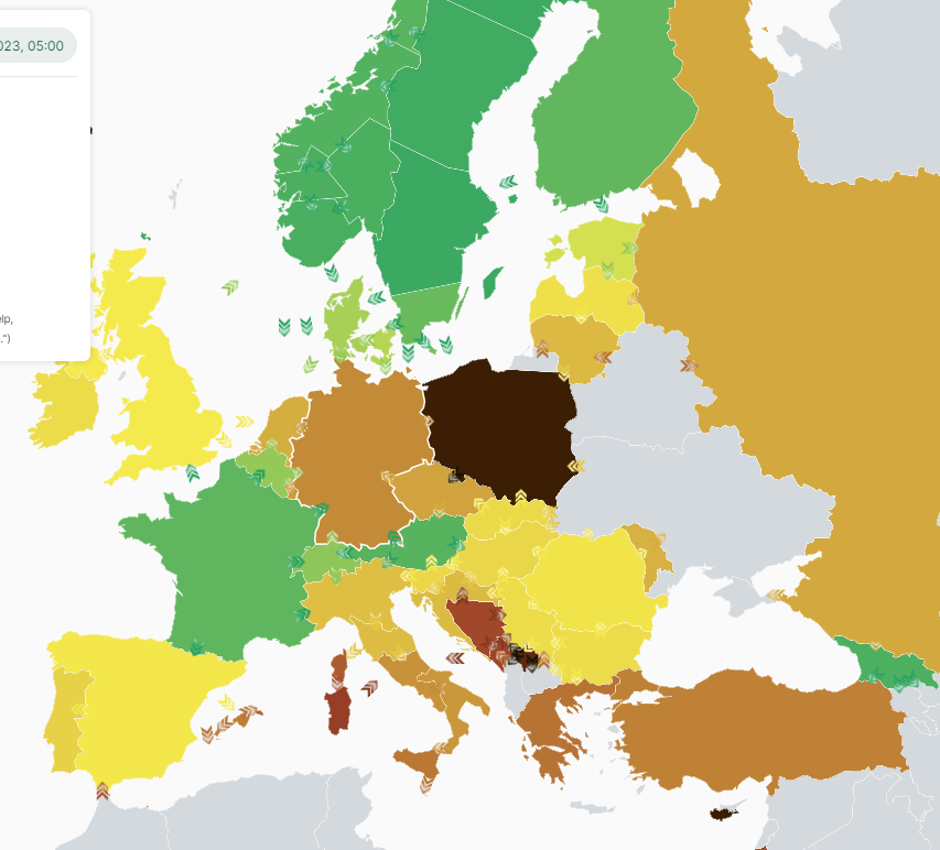
Die Webseite Electricity Maps schlüsselt die Stromerzeugungsarten von Deutschland und anderen europäischen Ländern auf. Heute, am 24.6.2023, dominiert bislang die Kohle:
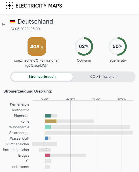
Im europaweiten Vergleich liegt Deutschland eher im hinteren Teil des Feldes, mit zu diesem Zeitpunkt 408 g spezifischen CO2-Emissionen (braune Farbe). Frankreich, Skandinavien und Österreich/Schweiz haben die geringsten Emissionen bei der Stromerzeugung (grüne Farbe).
+++
Der Meeresspiegel steigt seit 10.000 Jahren, aktuell mit wenigen Millimetern pro Jahr. Verfechter des Klimaweltuntergangs malen große Überflutungsszenarien für die Küstenregionen. Aber glauben die Menschen daran? Verfängt der Klimaalarm? Wozu wurden Deiche erfunden? Die American Geophysical Union berichtet jetzt von einer bemerkenswerten Entwicklung. An den Küsten schafft sich der Mensch immer mehr Landfläche:
New land creation on waterfronts is increasing, study finds
Humans are artificially expanding cities‘ coastlines by extending industrial ports and creating luxury residential waterfronts. Developers have added over 2,350 square kilometers of land (900 square miles, or about 40 Manhattans) to coastlines in major cities since 2000, according to a new study.
The study reports the first global assessment of coastal land reclamation, which is the process of building new land or filling in coastal water bodies, including wetlands, to expand a coastline. The researchers used satellite imagery to analyze land changes in 135 cities with populations of at least 1 million, 106 of which have done some coastline expansion.
The study was published in the journal Earth’s Future.
„Population growth is not the only driver of coastal land reclamation,“ the study’s authors said. „We expect that reclamation would continue to be popular in places that not only experience urban growth but also are eager to re-brand themselves for reputation and revenue.“
Coastal land reclamation today is most common in the Global South, where many economies are rapidly growing. In the previous century and earlier, the Global North dominated the use of coastal land construction. The study found China, Indonesia and the United Arab Emirates added the most land area, with port extension being the most common reason for development. Shanghai alone has added about 350 square kilometers (135 square miles) of land. In the United States, by comparison, only Los Angeles has noticeably added land area in the last 20 years, with 0.29 square kilometers (0.1 square miles) built.
„It’s quite important to capture this,“ said Robert Nicholls, who researches climate adaptation at the University of East Anglia and is not an author of the study. „There are more and more people, and our footprint is going up. Inevitably, there are ecologic consequences.“
Lead author Dhritiraj Sengupta, a physical geographer at the University of Southampton, and his co-authors found that industrialization and a need for urban space have driven much coastal land reclamation, while a smaller proportion of expansion projects are for „prestige,“ such as the palm tree-shaped islands of Dubai.
About 70% of coastal land expansion has been carried out in low-lying regions that are likely to be exposed to extreme sea level rise by the end of the century. Both environmental impacts and projected coastal inundation suggest these developed coastlines are not sustainable, but cities will likely continue to build them, the authors said.
Some cities, including Shanghai, are building new land while considering future sea level rise, Sengupta said. However, selling a development as „green“ is easier than selling it as an adaptation to sea level rise, he said. Evaluating the height of new land on a global scale is difficult. Doing so remains an interesting research question for scientists like Sengupta.
Ecological impacts
New land is typically created by piling sediments in the ocean, building cement sea walls and structures to contain sediments or cement, or by filling in wetlands and other shallow water bodies near the coast. These methods require vast volumes of sediment and disturb ecosystems irreversibly, as other research has established.
„The ecological impacts of reclamation are immense. Reclamation is a massive civil engineering project that fundamentally alters the characteristics of the space that it targets,“ Sengupta and his co-authors said. Coastal wetlands are particularly hard-hit. „In the Yellow Sea, for example, more than half of tidal flats were lost mainly due to reclamation.“
„Environmental consequences should be considered as part of the overall approval process“ for coastal land construction, Nicholls said. „The creation of land will make sense where it’s needed, but you have to do it in a responsible way … and think about whether it is really needed. Those are value judgments.“ Nicholls also noted that these projects make up a small fraction of the world’s coastlines and are often on already urbanized shores. By comparison, an estimated 14% of shorelines in the United States alone are „armored“ by seawalls and jetties.
Other environmental impacts include adding sources of point-source pollution, changing the patterns of sediment movement and altering the biosphere, all of which can impact ocean-based economies such as fishing and tourism. And unequal access to newly created shoreline can exacerbate class divides.
Reclamation also impacts distant ecosystems where fill materials such as sand and gravel are quarried. With a global shortage of sand, Sengupta noted, construction companies are quarrying sand and clay from the seabed, which destroys benthic ecosystems.
Paper: Dhritiraj Sengupta et al, Mapping 21st Century Global Coastal Land Reclamation, Earth’s Future (2023). DOI: 10.1029/2022EF002927
+++
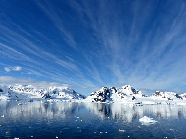
Auf der Antarktischen Halbinsel schmelzen die Gletscher. Noch nie dagewesen? Unter dem schmelzenden Eis kommt etwas Unerwartetes heraus, nämlich Reste von Moosen. Die wurden seinerzeit vom Eis überfahren, als die Gletscher vorstießen. Oder anders ausgedrückt: Die heute gerade erst wieder eisfreien Stellen waren bereits früher eisfrei gewesen. Die Moose kann man mit der C14-Methode altersdatieren und damit das Alter der Gletschervorstöße ermitteln. Das Ergebnis: In den letzten 1500 Jahren gab es drei große Gletscherwachstumsphasen, nämlich um 650 n. Chr. (Kältephase der Völkerwanderungszeit), 1150 n. Chr. (Ende der Mittelalterlichen Wärmeperiode, Beginn der Kleinen Eiszeit) und 1750 n. Chr. (Höhepunkt der Kleinen Eiszeit). All diese Gletschervorschübe und dazwischenliegenden Schmelzphasen ereigneten sich lange vor der Industriellen Phase und müssen von natürlichen Faktoren ausgelöst worden sein, die unabhängig von CO2 und Treibhausgasen sind. Die Klimamodelle können dies bislang nicht nachvollziehen, weil die Naturfaktoren bewusst auf nahezu Null gesetzt wurden. Ein schwerer Fehler. In der Pressemitteilung der University of Wyoming beschränken sich die Forscher selbstverständlich nur auf den Berichtsteil, die Datierung der Gletschervorstöße, ohne Einordnung dieser natürlichen Klimadynamik:
Study details timing of past glacier advances in Northern Antarctic Peninsula
Receding glaciers in the northern Antarctic Peninsula are uncovering and reexposing black moss that provides radiocarbon kill dates for the vegetation, a key clue to understanding the timing of past glacier advances in that region.
A University of Wyoming researcher led a study that determined the black moss kill dates coincide with evidence of glacier advances from other studies that found such events occurred 1,300, 800 and 200 calibrated years prior to 1950.
„We used radiocarbon ages, or kill dates, of previously ice-entombed dead black mosses to reveal that glaciers advanced during three distinct phases in the northern Antarctic Peninsula over the past 1,500 years,“ says Dulcinea Groff, a postdoctoral research associate in the UW Department of Geology and Geophysics.
Groff was lead author of a paper titled „Kill dates from re-exposed black mosses constrain past glacier advances in the northern Antarctic Peninsula“ that appeared Jan. 20 in Geology, a journal that publishes timely, innovative and provocative articles relevant to its international audience, representing research from all fields of the geosciences.
Researchers from Lehigh University, the University of Hawaii-Manoa, and Northeast Normal University and the Chinese Academy of Sciences, both in Changchun, in the Jiln Province of China, contributed to the paper.
Mosses are one of the few types of plants living in Antarctica and can become overridden and killed by advancing glaciers. The timing of when the glaciers killed the moss provides an archive of glacier history, Groff says.
For example, when glaciers expand or advance, they can entomb or cover the plant. This starves the plant of light and warmth. The date the plant died is the same time the glacier advanced over that location.
„As glaciers recede, these previously entombed mosses are exposed and are dead and black,“ Groff explains. „What’s so valuable about these kill dates compared to other records—like the ages of glacial erratics or penguin remains—is their accuracy. They provide a clearer picture of the climate history owing to their direct carbon exchange with the atmosphere and decreased error around the age estimate.“
Glacial erratics are glacially deposited rock that differs from native rock to a specific area.
The terrestrial cryosphere and biosphere of the Antarctic Peninsula are changing rapidly as „first responders“ to polar warming, Groff says.
„We know, from other studies, that large glaciers of the Antarctic Peninsula are responding quickly to warmer summer air temperatures, and scientists have modeled that the glaciers expanded in the past because of cooler temperatures, and not increased precipitation,“ Groff says. „However, we know much less about how this plays out at sea level where ice, ocean and sensitive coastal life interact. Knowing when glaciers advanced and retreated in the past would improve our understanding of biodiverse coastal ecosystems—thriving with seals, penguins and plants—and their sensitivity in the Antarctic Peninsula.“
Groff says one of the limitations of reconstructing glacier history is that there are few types of terrestrial archives that can be used to constrain past glacier behavior. Dead plants that have been reexposed, abandoned penguin colonies and rocks can be dated to better know the timing of permanent snow or glacier advance in the past.
During the summers of 2019 and 2020, the research field team, which included Groff, collected black mosses from Robert Island, Anvers Island, Charles Point and Cape Rasmussen, according to the paper. The group inspected and cleaned 39 black moss samples.
„We collected black mosses around the northern Antarctic Peninsula by exploring the edges of glaciers and nunataks at several locations. By radiocarbon dating the mosses, we found that glaciers advanced three times in the past 1,500 years,“ Groff says. „This is evidence for phases of cooler and potentially wetter conditions than today.“
On Anvers Island, Groff says the group learned that the last time the glacier was at its 2019 position was around 850 years ago as it expanded over the course of several centuries.
„Our estimates of glacier advance are much slower than recent retreat,“ she says. „Interestingly, we found that the glacier front with the fastest advance also had the fastest retreat, suggesting that hotspots of rapid coastal glacier dynamics occur in the Antarctic Peninsula.“
Groff says the dataset her research group has compiled is unique, citing it’s rare to have past net advance rates in the literature because glacial records tend to be destroyed when the glacier advances. Thus, these black mosses can reliably be used to estimate glacier advances in the past.
„There are other lines of evidence that support our moss kill dates for past cooler conditions such as peat records indicating lower biological productivity, as well as evidence for sea-level change from raised beaches as a result of changing ice mass,“ she says. „It’s also possible that the climate conditions that led to glacier advances involved wetter conditions and would have had a negative impact on penguins, as we know they do today. Many of the recent abandoned penguin colonies are the same age as our youngest black moss.“
Dulcinea V. Groff et al, Kill dates from re-exposed black mosses constrain past glacier advances in the northern Antarctic Peninsula, Geology (2023). DOI: 10.1130/G50314.1